

Applicant
Prof. Dr. Matthias Braun
Institut für Geographie
Friedrich-Alexander-Universität Erlangen-Nürnberg
Project Summary
Worldwide, dwindling glaciers threaten the livelihoods of millions of people and contribute to about one-third of the sea level rise currently occurring. In addition, the state of glaciers and ice caps outside the polar ice sheets is considered an indicator of global and regional climate change by the scientific community. This is emphasized by their listing as Essential Climate Variables (ECV) under the Global Climate Observing System (GCOS).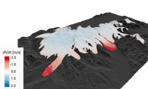
Nevertheless, the expansion of knowledge about the state and fate of the volume in these often barely accessible large ice systems is only recently gaining momentum. Remote sensing technology, with a variety of space-borne instruments, provides an exploding volume of data to exploit. Our project utilizes data from the TerraSAR-X add-on for Digital Elevation Measurement (TanDEM-X) mission to derive the surface elevation change of glaciers (c.f. figure) and thus their geodetic mass balance. To achieve global results, tens of thousands of gigabyte-sized data archives must be processed, which would require several months of computing time.
Therefore, the goal of the KONWIHR project COPI:GLECHA was to break up the structure of an existing processing pipeline to allow maximum parallel computing. Bottlenecks were reduced to a minimum by also outsourcing global pre-processing. The optimized implementation towards multicore processing further reduced the effectively required computing time.